
- Alpine Creek Trail is 3 miles long and climbs only 500 feet, but it takes you a good distance into the jagged Sawtooth Mountains.
- Pettit Lake – Hell Roaring Loop travels for 30 miles through forests, goes past several mountain lakes, climbs over high passes and visits meadows.
- Although the Forest Service has stopped to maintain the East Fork of the Big Wood River trail, the 4.6 mile trail is easy to follow and not very steep.
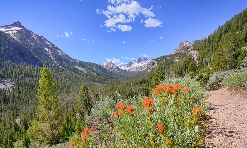
Overview
Close by lies the Sawtooth National Recreation Area and the Sawtooth Wilderness Area. Within the total of these areas are over 750 miles of trails and mountain peaks that rise over 10,000. The area is well known for its many hiking trails. With so many trials – the avid hiker will not likely become bored or even come close to exhausting the boundless possibilities for places to hike in and around the Sun Valley area. There are multi-day hikes for the more dedicated, adventuresome hiker. There are also many trails, which are only a few miles long, with a limited incline, which makes them great for day hiking. You might have the opportunity to see rock climbers using ropes and pitons on some of the rock cliffs, but the entire area is primarily a hiker's paradise.
Alpine Creek
Trail Overview: The scenery is exquisite, although there are no lakes by the trailside. The trail is 3 miles long and not very steep, climbing only 500 feet, but it takes you a good distance into the jagged Sawtooth Mountains. Trailhead: After traveling past Alturas Lake, the paved road will end and turn into a narrow dirt road. This leads to the Alpine Creek Trailhead which consists of your typical dirt parking area and Forest Service provided parking.
- Length: 6 total miles
- Elevation Gain: 560 feet
- Trail Type: Out-and-back
- Skill Level: Moderately easy
- Duration: Day hike
- Season: Best July through September
Baker Lake
Trail Overview: It’s a fairly easy hike to the lake. The trail is obvious all the way as it climbs, quite steeply, through flower-filled meadows to the lake. Trailhead: Drive 15 miles north of Ketchum to Baker Lake road, turn left and drive an additional 9.5 miles on the improved road to the trail head.
- Length: 2.5 total miles
- Elevation Gain: 916 feet
- Trail Type: Out-and-back
- Skill Level: Moderately easy
- Duration: Day hike
- Season: Best July through September
Blue Bunch Mountain
Trail Overview: The hike to the summit ridge of Blue Bunch Mountain gives a splendid view of the Dagger Falls portion of the great Middle Fork Canyon; the expansive Poker, Bruce, and Ayers Meadows and meandering Bear Valley Creek to the west; the rugged mountains of the Soldier-Langer Lakes area to the east; and Cape Horn Mountain to the south. Trailhead: From Idaho Highway 21, turn onto a well-marked road a few miles east of Banner Summit which climbs to Cape Horn. Follow this road for 12 miles to the side road to Fir Creek Campground. Stay to the left on the road until you reach the Bear Valley Campground, where you will find the trailhead.
- Length: 8 total miles
- Elevation Gain: 2,383 feet
- Trail Type: Out-and-back
- Skill Level: Moderate
- Duration: Either a day hike or overnight
- Season: Best mid-July through August
Boulder Chain Lakes
Trail Overview: This hike has deep, cool forests, mountain springs, lakes to fish or swim, mountains to climb. Trailhead: From Stanley, Idaho, we drove north on Highway 75 to the road leading up the East Fork of Salmon River. Shortly after leaving the pavement turn right on the road to Livingston Mill, which is an operating mine. The trailhead is 35 miles from Challis.
- Length: 20 total miles
- Elevation Gain: Minimal
- Trail Type: Out-and-back
- Skill Level: Moderately difficult
- Duration: Backpack
- Season: Best mid-July through August
Boundary Creek
Trail Overview: This is a steep trail, which quickly climbs to fine views of the Mount Heyburn area of the Sawtooth Range just across the valley. Trailhead: The Boundary Creek trailhead is 5.5 miles south of Stanley, across the road from the Sawtooth fish hatchery.
- Length: 11 total miles
- Elevation Gain: Minimal
- Trail Type: Out-and-back
- Skill Level: Difficult
- Duration: Day hike
- Season: Best July through September
Cape Horn Mountain
Trail Overview: As the most southerly point in the Salmon River Mountain Range, the frequently scaled Cape Horn Mountain provides an outstanding vista of the Frank Church-River of No Return Wilderness and the nearby Sawtooth Mountains. Trailhead: Merge off State Highway 21 onto a gravel road a few miles east of Banner Summit. Drive to Cape Horn Summit and park on the road’s left side. Locate the Trail 024 Trailhead under the trees at Cape Horn Summit. Cross the road to take the trail leading to the northeast.
- Length: 7 total miles
- Elevation Gain: 1,894 feet
- Trail Type: Out-and-back
- Skill Level: Moderately strenuous
- Duration: Either a day hike or overnight
- Season: Best mid-July to mid-August
East Fork of the Big Wood River
Trail Overview: The Forest Service seems to have stopped maintaining this trail. There are no signs, but the trail is obvious, not very steep, and easy to follow most of the time. Trailhead: Travel 5.5 miles north on Highway 75 and turn into the East Fork Road. Travel 6 miles up the road and keep to the right at the junction. At the next Y in the road stay to the left. Stay to the left for another 5 miles until you reach the trailhead.
- Length: 4.6 total miles
- Elevation Gain: Minimal
- Trail Type: Out-and-back
- Skill Level: Moderately easy, but very difficult to Johnstone Pass
- Duration: Day hike
- Season: Best July to mid-September
East Pass Creek
Trail Overview: A hike to a large waterfall, good views, and many elk located on the lesser known east side of the Boulder Mountains. Trailhead: From Ketchum, drive to the top of Trail Creek Summit and then 8 miles beyond that to Summit Creek. Turn off the main road onto Forest Road 444. Turn again at Forest Road 477 and continue on to the trailhead.
- Length: 19 total miles
- Elevation Gain: Minimal
- Trail Type: Out-and-back
- Skill Level: Moderate for the out-and-back; strenuous for the near loop into Herd Creek and back to the North Fork of the Big Lost River
- Duration: Multiday backpack
- Season: Best July
Fourth of July Creek to Born Lakes
Trail Overview: Stunning views of the White Cloud Peaks; numerous subalpine lakes. This is a busy hike, especially the first 1.3 miles to beautiful Fourth of July Lake. Trailhead: The trailhead is located by following Idaho hwy 75 about 15 miles south of Stanley. After crossing fourth of July creek the gravel road access is on the left. The trailhead is about 15 miles at the end of this road. The parking area is large with unloading ramps and toilet facilities. A Sawtooth Recreation trailhead pass is required.
- Length: 8 total miles
- Elevation Gain: Minimal
- Trail Type: Out-and-back
- Skill Level: Moderate, unless early in the season when snowfields must be crossed on the last leg of the hike to the Born Lakes
- Duration: Backpack
- Season: Best mid-July through early September
Fall Creek
Trail Overview: A relatively easy day hike to the edge or a two- or three-day rugged trip to the seldom-visited head of Fall Creek Canyon. Trailhead: Take Highway 75 (main street) to Sun Valley Road. Turn northeast onto the Sun Valley Road. This road turns into Trail Creek Road (closed in winter). Follow this road to the Copper Basin Road. Turn right on the Copper Basin Road. Follow this road 2 miles to the Wildhorse Creek Road. Stay to the right on the Wildhorse Creek Road. Follow the Wildhorse Creek Road 3.5 miles to the Fall Creek Road. Turn left on the Fall Creek Road and follow it 1.5 miles to the trailhead.
- Length: 8 total miles
- Elevation Gain: Minimal
- Trail Type: Out-and-back
- Skill Level: Moderately easy to the Left Fork; difficult to the head of Fall Creek
- Duration: Either a day hike or overnight
- Season: Best mid-June to mid-July to Left Fork; August to mid-September to head of canyon.
Fall Creek to Surprise Valley
Trail Overview: Glaciated mountain scenery with several small lakes. Trailhead: Take Highway 75 (main street) to Sun Valley Road. Turn northeast onto the Sun Valley Road. This road turns into Trail Creek Road (closed in winter). Follow this road to the Copper Basin Road. Turn right on the Copper Basin Road. Follow this road 2 miles to the Wildhorse Creek Road. Stay to the right on the Wildhorse Creek Road. Follow the Wildhorse Creek Road 3.5 miles to the Fall Creek Road. Turn left on the Fall Creek Road and follow it 1.5 miles to the trailhead.
- Length: 6 total miles
- Elevation Gain: 2,048 feet
- Trail Type: Out-and-back
- Skill Level: Moderately difficult due to the steep climb
- Duration: Overnighter
- Season: Best July to mid-September
High Ridge Trail
Trail Overview: Provides great views of the Pioneer Mountains, the Boulder Mountains, and Trail Creek Gorge. Trailhead: From Ketchum, drive to the top of Trail Creek Summit and on to Park Creek Road. Turn left onto Park Creek Road to the Cold Canyon Road. The trailhead is located near the entrance to Cold Canyon.
- Length: 6.4 total miles
- Elevation Gain: Minimal
- Trail Type: Out-and-back
- Skill Level: Moderately strenuous because of the climb
- Duration: Day hike
- Season: Best early July to Rock Roll Point. The trail to Basin Gulch is accessible as soon as you can ford Trail Creek. Late September is the end of the season.
Hyndman Creek
Trail Overview: You’ll be surrounded by wildflowers early in the year with tremendous views at all times. Trail Head: Turn east onto the East Fork Wood River Road from Highway 75. The turnoff is about 5.5 miles south of the town of Ketchum. Reset your odometer. You will reach the small village of Triumph at 5.8 miles, just keep heading east on the road. Shortly after Triumph the road becomes dirt. Continue east on the road when you see the turn-off for the Hyndman Creek trailhead at 7.2 miles. Take a left onto Forest Service road 203 at the fork. Follow 203 until it meets up with the confluence of the North Fork Hyndman Creek and Hyndman Creek and the trailhead.
- Length: 8 total miles
- Elevation Gain: 2,560 feet
- Trail Type: Out-and-back
- Skill Level: Moderately easy to the base of Cobb Peak. The last 2 miles to the base of Hyndman Peak are strenuous. Duration: Long day hike or overnight
- Season: Best July to mid-September
Iron Bog Trail
Trail Overview: The hiking distance to the two lakes is not great. These two aspects—scenery and relative ease—make the area a bit crowded sometimes. Trailhead: From Mackay, go 14 miles southeast on US 93, then 23 miles southwest on Antelope Creek Road, Forest Road 135 and FR 137.
- Length: 5 total miles
- Elevation Gain: 1,467 feet
- Trail Type: Out-and-back
- Skill Level: Moderately easy
- Duration: Either a day hike or overnight
- Season: Best July
Lightning Creek
Trail Overview: Meandering along creeks through narrow canyons and tree-lined meadows into some of Idaho’s most rugged country, this trail requires hikers to ford several streams before reaching the final destination at Lightning Lake. Trailhead: From Stanley, drive 13 miles east on State Highway 75 and exit at Sunbeam. Proceed north on a paved, two-lane road (which turns to gravel in 3 miles) up the Yankee Fork of the Salmon River. Reach the ghost town of Bonanza 7.5 miles north of Sunbeam and bear left on Forest Road (FR) 074. Drive past the Forest Service Guard Station, and at the fork in the road, follow the road leading to “Boot Hill Cemetery.” Drive downhill one mile to the West Yankee Fork Trailhead to locate the gated trail.
- Length: 16 total miles
- Elevation Gain: 2,190 feet
- Trail Type: Out-and-back
- Skill Level: Moderately strenuous
- Duration: Backpack
- Season: Best July through mid-September
North Fork of the Big Wood River
Trail Overview: Numerous wildflowers, springs, cascades, and avalanche runs, which open the forest for views of the rugged scenery. Trailhead: North on Highway 75 from Ketchum to the SNRA headquarters. Take the road 5 miles up North Fork Canyon to the trailhead.
- Length: 8 total miles
- Elevation Gain: Minimal
- Trail Type: Out-and-back
- Skill Level: Easy to the bend in the canyon (two miles). Moderate above the bend due to an increasingly faint trail and steeper grade; strenuous from the head of the canyon to Ibex Pass due to elevation gain.
- Duration: Either a day hike or overnight
- Season: Best late June through September to the head of the canyon; mid- to late summer to Ibex Pass, depending on snowline
Pettit Lake – Hell Roaring Loop
Trail Overview: The route wanders through attractive forests, goes past several beautiful mountain lakes, climbs over high passes with great views, and visits meadows with a wealth of wildflowers. Trailhead: Follow highway 75 south from Stanley, Idaho about 15 miles to the Pettit Lake turnoff on the right. Follow this graveled road, bearing right at the intersection to the Pettit lake campground. Just passed the campground is the large parking area for the trailhead.
- Length: 30 total miles
- Elevation Gain: 6,000 feet
- Trail Type: Loop
- Skill Level: Moderate backpacking
- Duration: 3 - 4 days
- Season: Usually open July to October; best mid-July through August
Toxaway - Pettit Loop
Trail Overview: The loop encounters all the features that have made the Sawtooths famous: toothed peaks, glacial boulders, large and small mountain lakes, avalanche runs, talus slides, granite cliffs, mountain meadows, waterfalls, cascading streams, and dense stands of lodgepole pine. Trailhead: Follow highway 75 south from Stanley, Idaho about 15 miles to the Pettit Lake turnoff on the right. Follow this graveled road, bearing right at the intersection to the Pettit lake campground. Just passed the campground is the large parking area for the trailhead.
- Length: 18 total miles
- Elevation Gain: Minimal
- Trail Type: Loop
- Skill Level: Moderately strenuous
- Duration: Backpack
- Season: Best late July to mid-September
White Cloud Peaks Loop
Trail Overview: This magnificent loop hits only a sampling of the best of these peaks. Trailhead: From Challis, go 18 miles southwest on US 93 and ID 75, then 18 miles south on East Fork Road (Forest Road 120).
- Length: 28 total miles
- Elevation Gain: 5,900 feet
- Trail Type: Loop
- Skill Level: Moderate to difficult backpacking
- Duration: 3 - 5 days
- Season: Usually open mid-July to October; best late July to September