- The Salmon-Challis National Forest has 4.3 million acres of remote forested area.
- The Forest contains 1/3 of the 2,353,739-acre Frank Church-River of No Return Wilderness.
- There are 26 developed campgrounds on the Salmon-Challis Forest with over 260 individual campsites.
- Activities include camping, hiking, backpacking, fishing, whitewater rafting, horseback riding and hunting.
Overview
Covering over 4.3 million acres in the east-central area of Idaho, is the Salmon-Challis National Forest. The Forest contains 1/3 of the 2,353,739-acre Frank Church-River of No Return Wilderness, the largest wilderness in the U.S. outside of Alaska.
This rugged, remote country invites travelers to experience adventure, awe-inspiring scenery and solitude. For the ultimate outdoor adventure, plan a trip to the Salmon-Challis National Forest.
Location & Information
The Salmon-Challis National Forest covers 4.3 million acres of central Idaho, from the Middle Fork of the Salmon Wild and Scenic River to the Continental Divide National Scenic Trail in the Bitterroot Mountains.
Salmon-Challis National Forest
Phone: (208) 756-5100
Website: www.fs.usda.gov/scnf
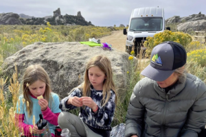
Activities
The Salmon-Challis National Forest is expansive. Found in the east-central area of Idaho, these 4.3 million acres of remote forested area is a haven for outdoor recreation enthusiasts. Included within the boundaries of the Forest are Idaho's highest peak, Mount Borah, and wild, scenic rivers including the Salmon River, and the Middle Fork of the Salmon River.
Hiking and Backpacking
There are over 1,600 miles of trails crisscrossing the Forest, including the Knapp Creek-Loon Creek Trail and the Mill Creek Lake Trail, which have been designated as National Recreation Trails.
- Knapp Creek-Loon Creek Trail
This trek contains some of the most scenic terrain in the entire wilderness. The jagged peaks here rise above 10,000 feet and are made up of a stunningly beautiful collage of gray, white, and reddish rocks. When you add this colorful geology to the area's unique lakes, clear streams, and flower-covered meadows, you have a great place to go for a backpacking vacation.
Length: 27 total miles
Elevation Gain: 6,100 feet
Trail Type: Loop
Skill Level: Moderate to difficult backpacking
Duration: 3 - 4 days
Season: Usually open July to October; mid-July to September - Mill Creek Lake Trail
Mill Creek Lake, in the rugged Lemhi Mountains, is usually suitable for a hike and overnight camping in the early part of the hiking season. Rocks and cliffs enclose the lake which was created by a land slide. A hint of a trail above the lake leads to Firebox Meadows and Firebox Summit.You can usually reach the lake by mid-June, although July and August are the best months to visit.
Length: 10.5 total miles
Elevation Gain: 1,778 feet
Trail Type: Out-and-back
Skill Level: Moderate to the lake; moderately strenuous to Firebox Meadows due to a trail that is faint in some crucial places.
Duration: Either a day hike or overnight
Season: Best July through August
Camping
Developed camping is available for those who prefer to drive to their campsites. There are 26 developed campgrounds on the Salmon-Challis Forest with over 260 individual campsites. Dispersed or primitive camping is available throughout the Forest at no charge. Visitors are asked to pack out their litter and garbage. Each campground has its own special attraction. The following is just a sampling.
- Boundary Creek
Fourteen campsites on the Middle Fork of the Salmon River. Take out for floaters coming from Marsh Creek; put in for those floating the Wild & Scenic section to Cache Bar. Trail from campground heads into the Frank Church River of No Return Wilderness.
Location: From Stanley, go 20 miles northwest on ID 21, 11 miles west on FR 198, and 13 miles north on FR 668 (Boundary Creek Rd.).
Season: June – September
Fee - YES
Reservations: NO - Mosquito Flat Reservoir
Three picnic sites on the shore of Mosquito Flat Reservoir. Yankee Fork Trail (#147) provides access to the Frank Church River of No Return Wilderness about 2 miles west of the reservoir. Developed campground adjacent to the reservoir has 9 sites.
Location: From Challis, go 13 miles west on Forest Road 070 then 4 miles north on FR 080.
Season: June-September
Fee – NO
Reservations - NO - Mill Creek Trailhead Campground
Six campsites and a stock loading ramp. Trailhead for trail which heads up Mill Creek to Firebox Summit, looping back on the Main Fork Little Lost River. Dispersed camping permitted in designated areas. Fishing in area creeks.
Location: From Mackay, go 7 miles south on US 93, 28 miles northeast on Pass Creek Road (Forest Road 122), 10 miles north on Sawmill Canyon Road (FR 101).
Season: June – September
Fee: NO
Reservations: NO
Other recreation activities in the Forest include whitewater rafting, fishing, hunting, and even visits to the historic ghost towns of Custer and Bonanza.